Written by Dries Bonte.
DuneFront is a European project that aims to enhance coastal protection and safety by creating and optimizing hybrid coastal protection solutions that combine natural dunes with engineered dikes, with the potential for increased resilience in a changing climate. These Nature-based Solutions aim to safeguard coastlines from flooding while boosting biodiversity and recreation. By studying 12 sites spread across six European countries, building digital and physical models, and co-creating a new prototype in Belgium, DuneFront develops tools, blueprints, and a rating system to guide sustainable coastal infrastructure. It engages citizens and stakeholders to mainstream biodiversity in future coastal planning.
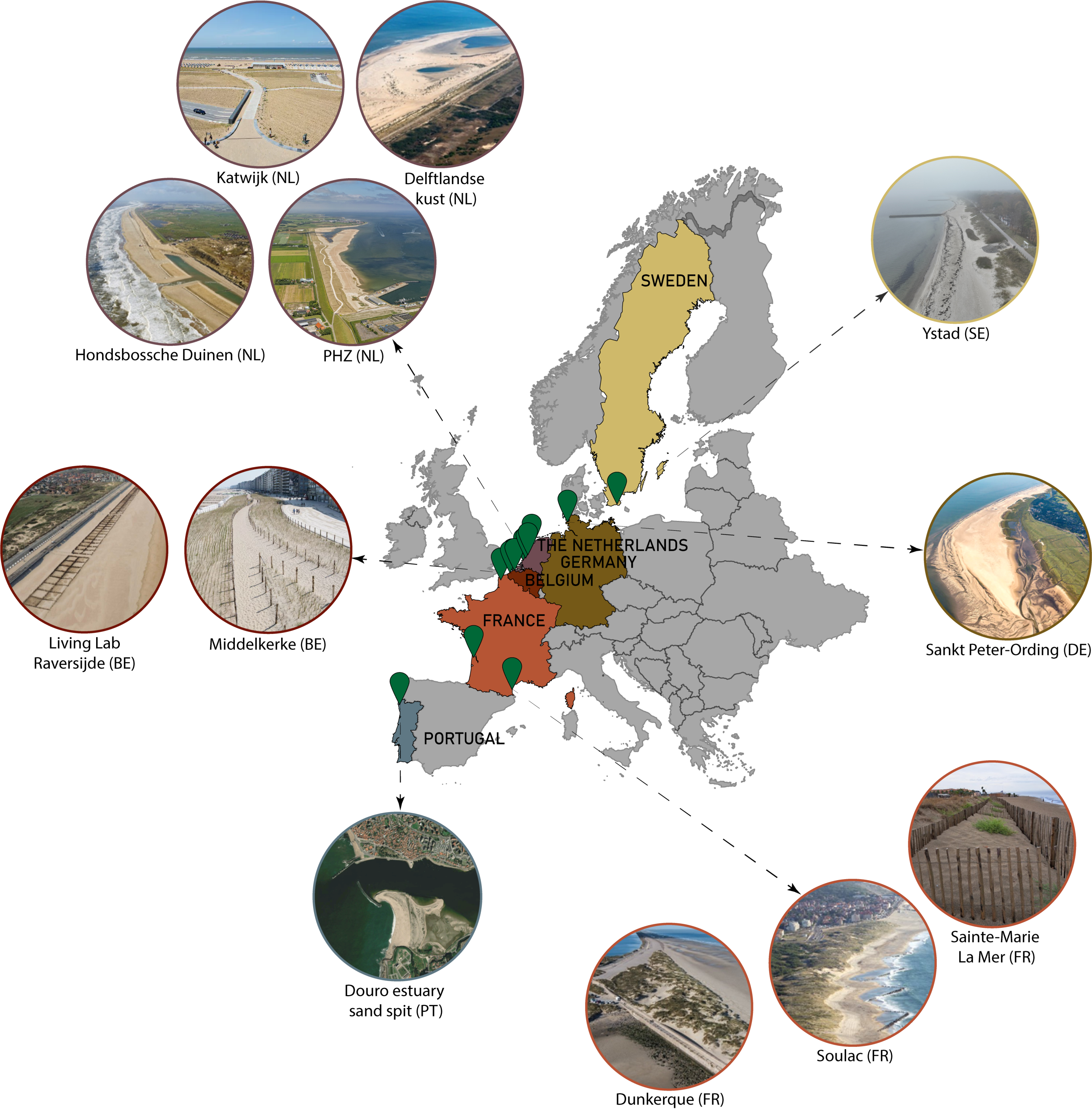
Introducing the demonstrators
At the heart of DuneFront are twelve demonstrator sites spread across six European countries: Portugal, France, Belgium, the Netherlands, Germany, and Sweden (https://www.dunefront.eu/demostrator-sites). These sites represent a diverse array of coastal configurations, from dunes built in front of dikes to dikes embedded within dunes, and even standalone dune systems connected to grey infrastructure. Each demonstrator serves as a living laboratory, allowing researchers to study how these hybrid systems perform under varying environmental conditions and governance structures.
The demonstrators were selected for their potential to deliver multiple benefits: cost-effective flood protection, ecological restoration, and improved public amenities. They also reflect a range of design approaches, from traditional engineering to innovative, adaptive methodologies.
Biodiversity: Mapping, monitoring, and enhancing coastal life
Although the dedicated biodiversity deliverables are still pending, substantial progress has already been made under Work Package 5, which focuses on evaluating the ecological performance of DuneFront’s hybrid dune-dike demonstrators. The project is pioneering a Europe-wide methodology to map and monitor the evolution of key coastal habitats, particularly those protected under the Natura 2000 framework. These include drift line, embryonic shifting dunes, shifting dunes , and fixed grey dunes. Using standardized aerial imagery and digital elevation models, researchers have delineated and classified dune habitats across nearly all demonstrator sites through advanced remote sensing and machine learning techniques.
In parallel, extensive fieldwork has been conducted to assess biodiversity patterns. Vegetation surveys and trait measurements were carried out across all demonstrators and matched control sites, capturing both aboveground and belowground ecological dynamics. These surveys were complemented by arthropod sampling, enabling a multi-trophic view of biodiversity. Early results suggest that demonstrator sites perform comparably to natural controls in terms of species richness, although differences in food web structure hint at more bottom-up dynamics in designed dunes. Connectivity analyses are underway to evaluate how well these hybrid systems support ecological linkages, both locally, at the beach-dune interface, and regionally, across fragmented urban coastlines. By restoring habitats, supporting diverse species, and enhancing ecological connectivity, the project is demonstrating that nature-based infrastructure can be both protective and regenerative.
What the sand tells us: Understanding morphodynamics
The first major research effort, documented in Deliverable D6.1 (https://www.vliz.be/en/imis?module=ref&refid=409899), focused on the morphodynamic evolution of the demonstrator sites. Using high-resolution digital elevation models (DEMs), researchers tracked changes in dune volume, elevation, and beach surface area over time.
The findings were encouraging. Most dunes showed significant sand accumulation after construction, particularly in the first year following beach nourishment. Even in areas where the upper beach experienced erosion, often due to storm events, the dunes themselves remained stable or continued to grow. This highlights their critical role in coastal defense. However, the results also revealed site-specific dynamics. For example, while five demonstrators saw an increase in surface area above the highest astronomical tide (HAT), seven experienced a decrease. The Ystad and Delflandse kust sites showed signs of erosion, underscoring the importance of local conditions and ongoing monitoring.
Designing for resilience: Lessons from the field
Deliverable D7.1 (https://www.vliz.be/nl/imis?module=ref&refid=396141) delved into the design methodologies behind seven selected demonstrators. The analysis revealed a wide spectrum of approaches, from basic, ad-hoc designs to sophisticated probabilistic models.
Sites like Katwijk in the Netherlands employed advanced modelling tools and reliability assessments to ensure long-term safety, while others, such as Sainte-Marie La Mer in France, relied on more intuitive, experience-based methods. This diversity reflects both the novelty of hybrid NbS and the evolving understanding of how best to integrate natural and engineered elements. One key insight was the lack of standardized methods for designing dunes and dikes as interconnected systems. Most designs treated them separately, missing opportunities to optimize their combined performance. The report calls for new modelling techniques that account for dune erosion, infragravity waves, and adaptive design principles.
Beyond protection: Unlocking multi-use potential
Deliverable D9.1 (https://www.vliz.be/en/imis?module=ref&refid=409913) explored the broader value of coastal NbS through a comprehensive literature review. It found that while biodiversity benefits are well-documented, other co-benefits such as recreation, tourism, and climate mitigation are often mentioned but rarely studied in depth. The review also identified significant barriers to implementation, including land-use conflicts, limited space, weak legal frameworks, and a lack of public understanding. At the same time, it highlighted promising drivers: participatory planning, hybrid solutions that require less space, and pilot projects that build trust and demonstrate effectiveness.
Importantly, the report emphasized the need for interdisciplinary collaboration. Designing successful NbS requires input from engineers, ecologists, planners, and local communities. Only by integrating diverse perspectives can we create coastal systems that are safe, sustainable, and socially accepted.
Looking ahead
The DuneFront project is still in its early stages, but its achievements so far offer a compelling vision for the future of coastal protection. By combining rigorous scientific analysis with practical design and stakeholder engagement, DuneFront is laying the groundwork for a new era of resilient, multifunctional coastlines.
As the project moves forward, existing deliverables will be tuned to policy papers to inform and influence decision-makers on the relevance of NbS, and to scientific publications to further advance knowledge and contribute to the scholarly discourse. Upcoming deliverables will deepen our understanding of vegetation-sediment interactions, environmental influences, and socio-economic impacts in our demonstrating sites. Together with ongoing efforts to gain a mechanistic understanding of the links between biodiversity, morphodynamics and socio-economics, these insights will help shape a comprehensive roadmap for implementing hybrid NbS across Europe and beyond.
---------------------------------------------------------------------------------------------------------------------------------------------------