Joint article written by Elisabet Ydman (UL), Alice Pohle (VLIZ), Coco Koedoder (VLIZ) and Adrien Cartier (Géodunes) and Line Debaveye (VLIZ).
DuneFront
Within the DuneFront project, research is done on multiple aspects (e.g. biodiversity, bioreceptiveness, withstanding extreme storms etc.) of dune-dike systems. One aspect we wish to highlight in this article is how dunes evolve over time while being exposed to the natural elements (winds, storms, tides etc.).
Checking coastline dynamics
Analyzing changes in the coastline is a challenging undertaking. Like other types of environmental research, coastal research needs large amounts of data. A common data collection method for coastal monitoring is to use satellite images. This provides data over vast areas; however, the data is not as frequent as it would need to be. Another data collection method that is used for coastal monitoring is advanced camera setups covering a small part of a coastline. Although these cameras offer more frequent and detailed data, they are very expensive, which means that it’s difficult to set them up in multiple places to get the bigger picture. A need within the scientific world arrives to generate more data in a standardized manner, and this is where Coastsnap comes in.
Coastsnap
CoastSnap is a global citizen science project where locals and tourists are encouraged to participate in the monitoring of beach and dune development.
By taking a picture through the installed holder and sending it - along with the date and time - to the responsible data manager, any passerby can contribute to a time-series of shoreline images. Matched to the correct tide data – comparing only pictures taking at the same tidal level - these images can then be analysed to understand if the beach is shrinking (eroding) or growing (sand accreditation). Where natural or deliberate (artificially planted) dune vegetation occurs within the CoastSnap photo frame, timelapse videos of the images also provide a powerful visual for the natural dynamics of aeolian transport of sand, vegetation growth and establishment of dunes!
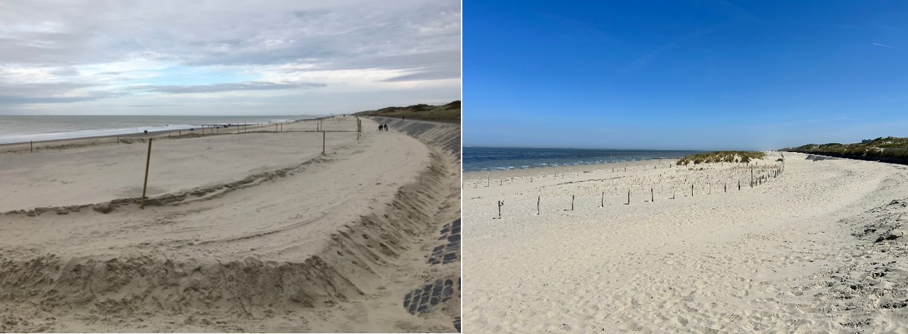
Dune development in Oostende Oosteroever, Belgium. Left: 21.10.2020; Right: 28.04.2025 (picture: VLIZ)
For locals, CoastSnap offers a way to interact and consider changes at the local beaches, fostering a sense of stewardship and participation in the monitoring, protection and management of the local shores. In fact, “local champions” – think the woman walking her dog every morning and stopping to snap a picture; or the man passing the site 3 times a week on the way to his favorite beach club – are an integral part of the success of CoastSnap. The more pictures collected on a continuous basis, the more nuanced the timeline and analysis of shoreline change!
For tourists on the other hand, CoastSnap is an easy way to engage with the environment they are visiting and can be a gateway to raising interest about initiatives that take the issue of coastal change from mere monitoring to active experimentation with nature-based-solutions – like DuneFront! Being a global project, awareness raising for CoastSnap in one part of the world can also heighten participation elsewhere, as the main logo and physical set-up is very recognizable.
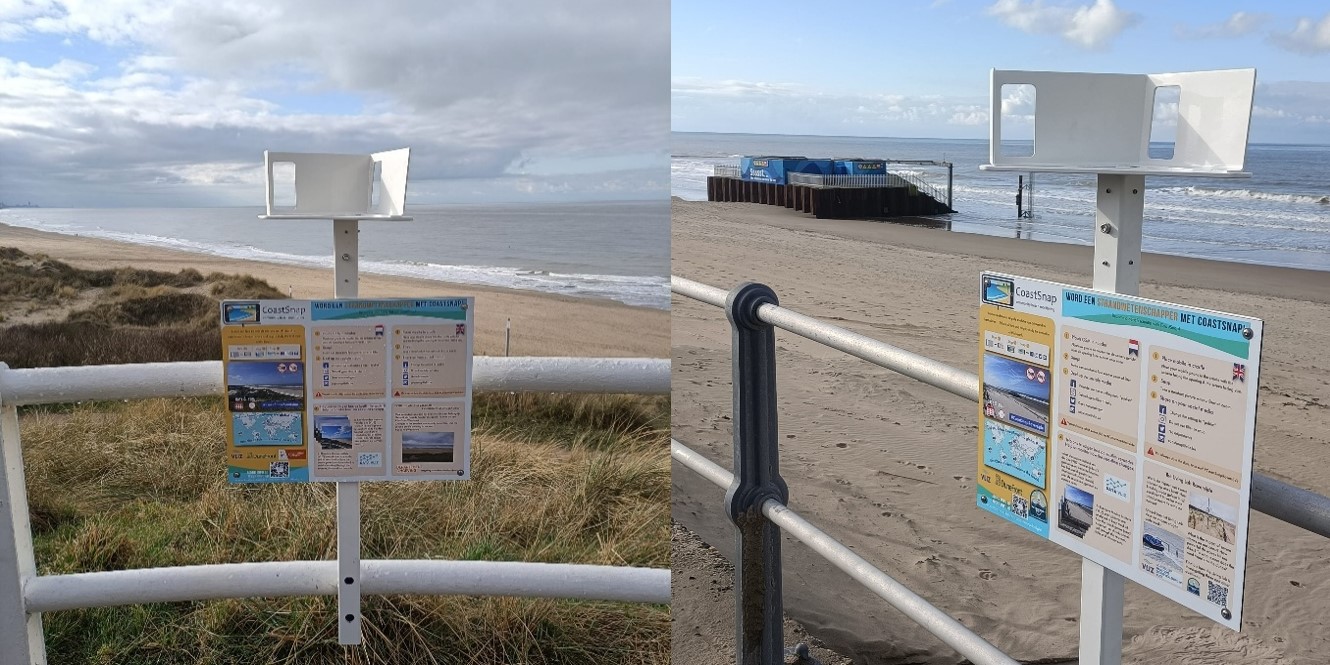
Wenduine and Raversijde stations in Belgium (picture: VLIZ)
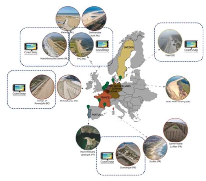
Besides the Belgian CoastSnap site at Raversijde, several other European CoastSnap stations are situated adjacent to DuneFront Demonstrator sites (see map below) – namely, in Sweden (Ystad), in the Netherlands (Hondbossche Duinen and Texel) and in France (Dunkirk).
In this article, we will take you through the use and research of Coastsnap within the DuneFront project.
Monitoring coastal dynamics at the DuneFront demosite at Dique des Alliés using Coastsnap
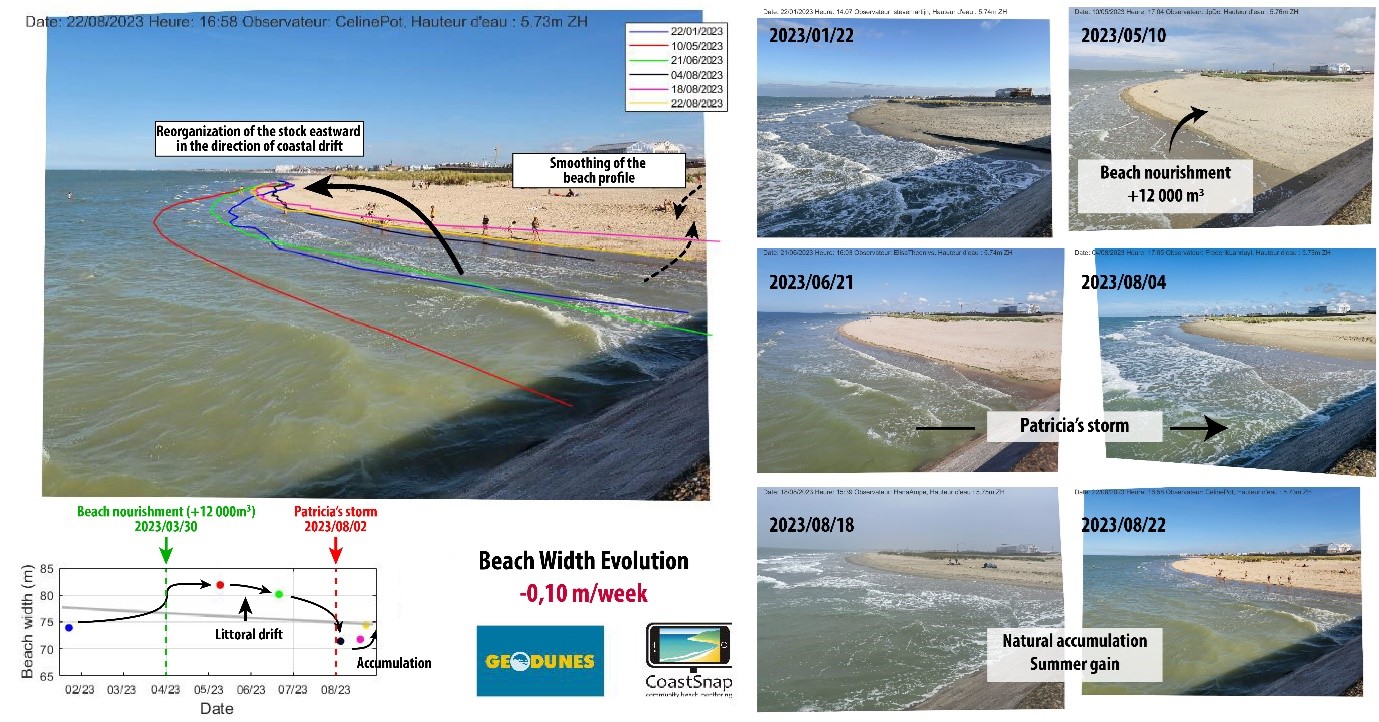
The CoastSnap station at the Digue des Alliés in Dunkirk, northern France, was installed in December 2022 by the engineering firm Géodunes, in collaboration with the Oceanography and Geosciences Laboratory (LOG UMR 8187) at the University of the Littoral Côte d'Opale (ULCO), on behalf of the Pôle Métropolitain de la Côte d’Opale. The purpose of this station is to conduct high frequency surveys in order to assess changes to the sandy beach located in the immediate proximity of the Digue des Alliés, a major component of the local flood defence system. In 2014, 1.5 million cubic metres of sandy sediments were replenished to the beach to protect the dike from the effects of sea water, particularly storm surges. Since 2019, regular maintenance replenishment (approximately 30,000 m³) has been carried out to limit the site's natural erosion. In this context, the CoastSnap station provides crucial information for short-term beach management while engaging the local community.
Photos taken by citizens are fed into a large database that highlights recurring management actions and their evolution. The digitized land-sea boundary obtained from the photos also serves as an indicator of the beach's health. Determining the position of the average high tide level in relation to the pier adjacent to the beach allows managers to take maintenance actions. As part of managing the CoastSnap station at the Digue des Alliés, Géodunes performs a weekly analysis of received photos to maintain increased vigilance over sand levels.
Following installation, the site has attracted major interest, with over 1,000 participants and 1,200 images collected, of which approximately 60% are usable.
Currently, the analysis of other indicators is underway, particularly the use of artificial intelligence technologies, to monitor other factors, such as vegetation evolution and the sand level variations at the base of the structure. With this analysis, the demonstrator site can be supervised over long periods of time while monitoring coastal dynamic parameters.
Researching stakeholder participation and public perception at the Swedish Coastsnap stations
CoastSnap started as a pilot project in Australia in 2017, and has since then expanded to more than 20 countries. Last summer, 2024, the first CoastSnap stations were installed in Sweden.
They were set up in three locations in the south of Sweden; Laholm, Båstad and Ystad – Ystad being one of the demonstrator sites in the DuneFront project. Within the project, research was done by the University of Lund (Elisabet Ydam), to check the public’s perception and interest in participating in CoastSnap in Sweden. The aim was to examine factors that could affect the public’s interest. Therefore, on-site interviews with passers-by were carried out at the CoastSnap-stations. The interviews were complemented with online surveys in local Facebook groups.
The study revealed a strong potential for public engagement with CoastSnap across all three study locations. While CoastSnap was not yet widely recognised, respondents who learned about the project expressed a very positive attitude toward it, with many showing genuine interest in participating. This demonstrates that there is an excellent foundation to build on once awareness increases.
Some respondents highlighted that clearer information and more visibility of the CoastSnap stations would make participation even easier—valuable insights that point to opportunities for improving communication and outreach. Encouragingly, many participants also shared detailed reflections on changes in the coastline, showing a high level of local knowledge about coastal dynamics. Tapping into this knowledge through CoastSnap could be a powerful way to strengthen coastal research while also empowering communities to contribute actively.
Overall, the findings highlight that while awareness can be further developed, there is significant enthusiasm and untapped potential for CoastSnap in Sweden. With improved outreach and accessibility, the project can grow into a highly effective tool for both science and community engagement. Having projects raising awareness about Nature-based Solutions is incredibly valuable in creating local support for these systems.
End notes
By linking the grassroots engagement of CoastSnap with the research of DuneFront, a powerful synergy emerges: citizens provide the continuous, localised data that scientists need, while researchers translate these contributions into actionable insights for sustainable coastal management. This collaboration not only strengthens scientific understanding of dune and shoreline dynamics but also builds community stewardship and awareness around nature-based solutions. Together, CoastSnap and DuneFront show how science and society can co-create resilience at the water’s edge—turning snapshots into long-term strategies for thriving coasts.