Written by Maxime Dahirel (UGhent).
The DuneFront project aims to mainstream dunes as Nature-based Solutions for coastal protection. To do so at large scale and in an evidence-based manner, it is necessary to understand where key dune plant species can or cannot develop, as coastal dunes are not just piles of sand, but dynamic sand-vegetation systems. A research team from Ghent University (Maxime Dahirel & Dries Bonte), published a key report in that direction, combining species data from citizen science platforms with environmental data previously curated by a University of Bordeaux DuneFront partner (Bruno Castelle). This report uses an innovative machine learning method to provide some of the first 1-km resolution maps of potential distribution for over 20 species of ecological interest across Europe.
Building distribution models
In ecology and conservation, Species Distribution Models is the name of a category of analysis methods allowing scientists to produce predictions of the absolute or relative suitability of different areas for a given species. There exists a wide and diverse range of such methods, which can be used to combine species records with environmental data to reconstruct ecological niches.
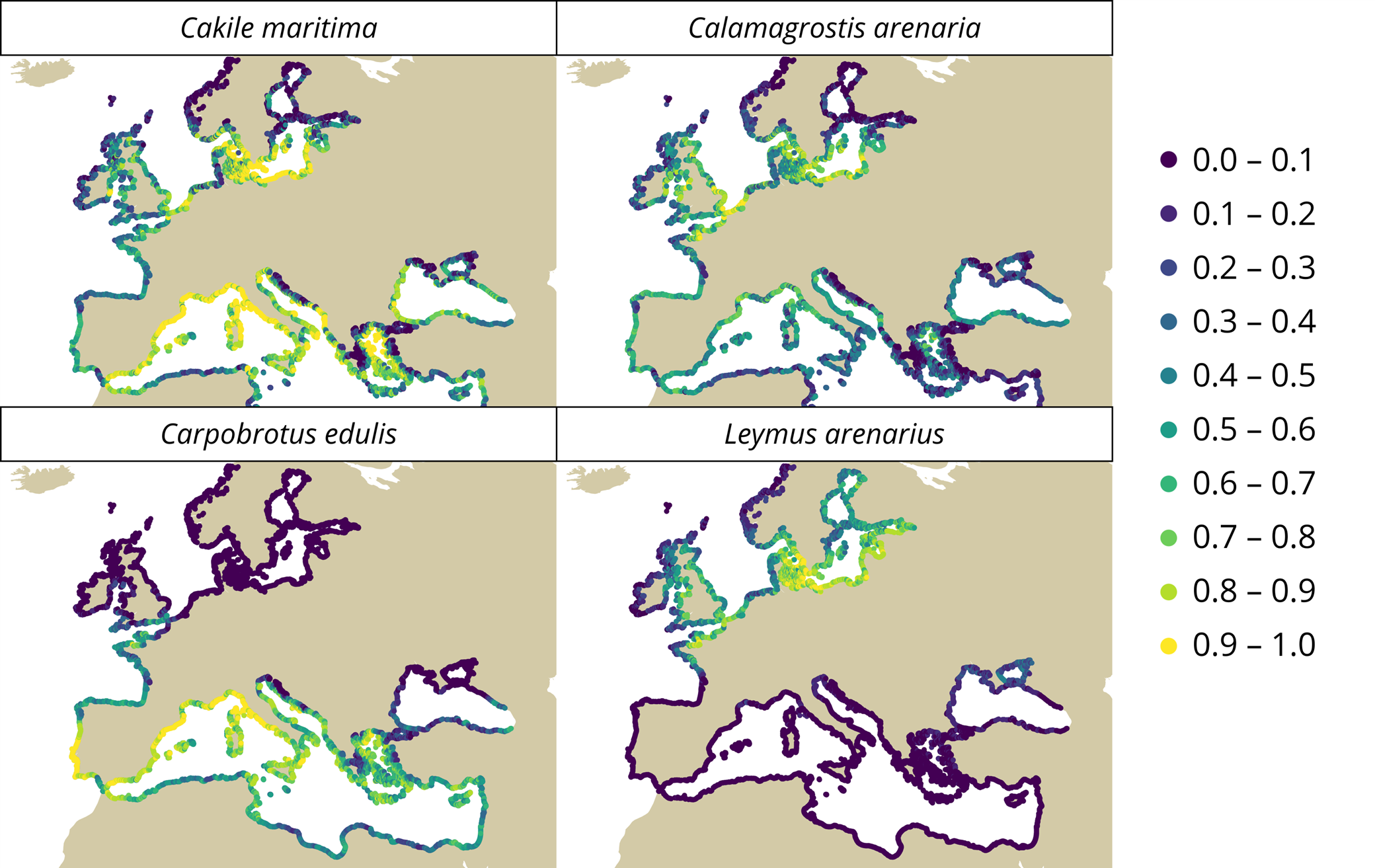
Here we used data from the citizen science platforms iNaturalist, Observation.org and Pl@ntNet for 20+ species of plants, including dune-building species, alien species and species of conservation importance (with respect to Annex I of the EU Habitats Directive). We combined these plant records with environmental data using an innovative machine learning method, Bayesian Additive Regression Trees (BART). Compared to other more established Species Distribution Models, BART is unique in that it allows to easily quantify the uncertainty of predictions, identifying where data may be lacking and further work needed.
Key results, and future perspectives
Our report shows that BART models successfully recover the broad patterns of species distributions across Europe. They also show that responses are highly variable between species, but that species share common drivers. Most species are generally responding to climate, wave dynamics and the intensity of storm surge. Whether or not a coastline is exposed or embayed is also a major predictor: calm embayed coastlines are generally less favourable to most dune plants. With caution, we can extrapolate these results to future climate, showing that dune species are expected to respond negatively to climate change at Europe scale.
Critically, our report and BART models highlight uncertainty in predictions: we generally can broadly predict places that are fully unsuitable, but finer scale predictions within the generally suitable area tend to be more uncertain and unreliable. Furthermore, some species were underrecorded compared to the others in citizen science databases, making their prediction less precise. Differences in the aesthetic appeal of species may play here a role. New data collection, including what is done in the rest of the DuneFront project, could help refine these predictions and make them more useful to stakeholders.
In parallel, extended analysis work is ongoing to better account for the effect of urbanization on species distribution (given the higher relevance of coastal protection to densely populated areas), and to use plant traits to make better predictions.
REPORTS
Full report (DuneFront deliverable D4.2): https://zenodo.org/records/15173628/files/DuneFront_D4.2_v1.0.pdf?download=1
Associated report on environmental data (DuneFront deliverable D4.1): https://zenodo.org/records/14525766/files/D4.1_Physical_boundary_conditions_v1.0.pdf?download=1
---------------------------------------------------------------------------------------------------------------------------------------------------